Pranav Bhat
By

Ladakh, also known as little Tibet was an area prohibited to both foreign and Indian visitors until the mid 1970s and the lack of much development or industrialisation in the modern era has ensured the preservation of natural environment.
Situated between the great landmasses of Central Asia and Mainland India, Ladakh formerly provided the gateway for trade between these two regions and was a vital link from India to the Central Asian Silk Route running from China to Europe. The traders who used this route were the only source of contact that Ladakh had with the outside world. Along with the wealth they generated, it was also the knowledge and culture of the neighbouring regions that the traders brought with them that was of remarkable importance.

Leh Bazaar prior to 1871
Ladakh is dominated by mountain ranges, specially by the Himalayas and Karakoram ranges. Within Ladakh, the highest peaks are the Nun and Kun in the Suru Valley at an altitude of over 7000m. In Ladakh's higher reaches, even the valleys are at an altitude of around 4000m and 5000m and can sustain only scrub like vegetation that has the ability to withstand the intense cold of the winter.
Ladakh is bound by the Himalayas to the south and the Karakoram ranges to the north which runs roughly parallel to the Himalayan ranges. Central Ladakh lies in the area between these two great mountain ranges in what is known as the River valley because of the rivers that descend from them.
There are several other smaller ranges in the area such as the Ladakh range which are really only sub-ranges of major ones. The Ladakh range runs West to East through Central Ladakh until it merges with the impressive Pangong Range and continues on into Tibet as the Kailash range.
The Zanskar range runs parallel to and just North of the great Himalayan range in the Suru valley which at Kargil forms the western boundary of Ladakh. To the East, Ladakh rises into and bounded by the great, high altitude Tibetan plateau known as the Changthang. It is now believed and understood that these ranges were formed around 30 to 40 million years ago when India was then still an island called the Gondwana crushed into the Eurasian landmass.

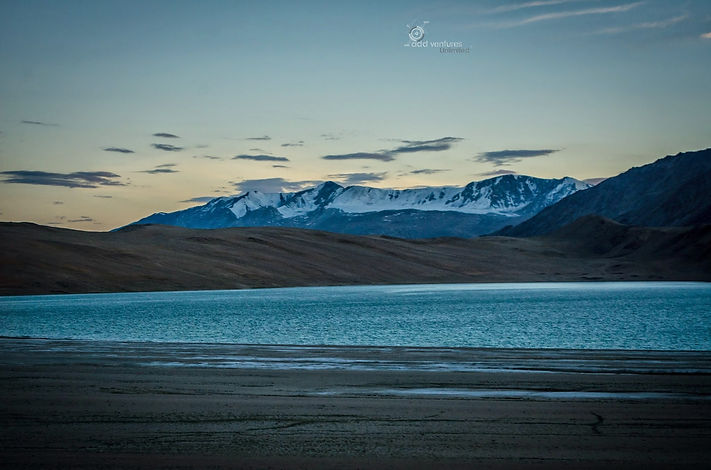
The beautiful architecture of Ladakh seemingly imitates the natural shapes of the landscapes embracing the scene further and perhaps most impressive of all to the eye, the lakes. The high altitude lakes of Ladakh and Tibet contain extremely clear water that reflects the colours of the sky and turns the water into shimmering pools of greens, blues and violets.
The largest and most spectacular of these lakes is the Pangong Tso at an altitude of 4246m. Although no wider than a few kilometers, it is 125Km long and straddles the border with Tibet. The route to the Changthang passes in the Pangong mountain range is one of the most dramatic in the region.

Ladakh is naturally divided into many districts by the nature of its mountains and river valleys altough officially it has been split in just two of which one is Leh and the other, Kargil. Central Ladakh, where the majority of Ladakh's population lives sets aside the course of the Indus River Valley as it emerges from Tibet. To the North of the Indus valley, after crossing the Khardung pass, one descends to Nubra district, which contains two main valleys, the Shyok Valley and a river which runs from East to West; and the Nubra valley with a river then runs South from the heights of Karakoram range until its confluence with the Shyok river.
Nubra valley is situated at a lower altitude than the Indus valley and with its moderate climate is more fertile and lush than the rest of Ladakh.

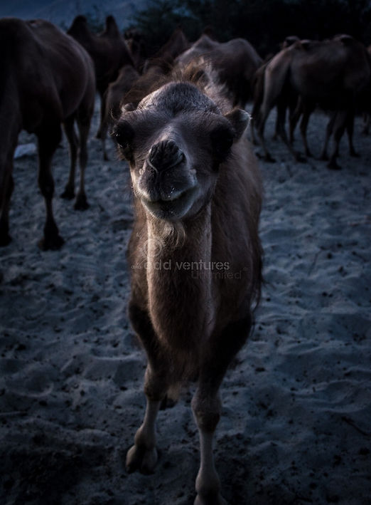
The valley is also home to a few currently unemployed Bactrian double-humped Camels that were used as pack animals by the traders travelling this route, hundreds of years ago. They love grazing the thickets of Buckthorn bushes that flourish in the Sand dunes onthe banks of Shyok river.
To the south and west of Ladakh lies the sparsely populated Zanskar district which like Nubra, houses two river systems.While most of Ladakh receives relatively less snowfall due to minimum precipitation, Zanskar recieves very heavy snowfall during winter. Snowfall causes Zanskar to remain cut off from the rest of Ladakh during winter.
To the East of Ladakh lies the sparsely populated Changthang.
South-east of Leh and bordering the Himachal Pradesh to the south and Tibet to the east is Rupshu district which is an area of high altitude mountains, lakes and grassy plains suitable for grazing. All these factors make it an ideal place to reside for the Chang Pa nomads as well as some wildlife.
Of the animals found in this region, a few that are sometimes sighted are the Tibetan Ass (a.k.a Kyang), Marmot, Ibex, a variety of goats and sheep and a surprising number of migratory birds that choose these remote lakes as summer breeding grounds.